1.14 County supervisory district 14.
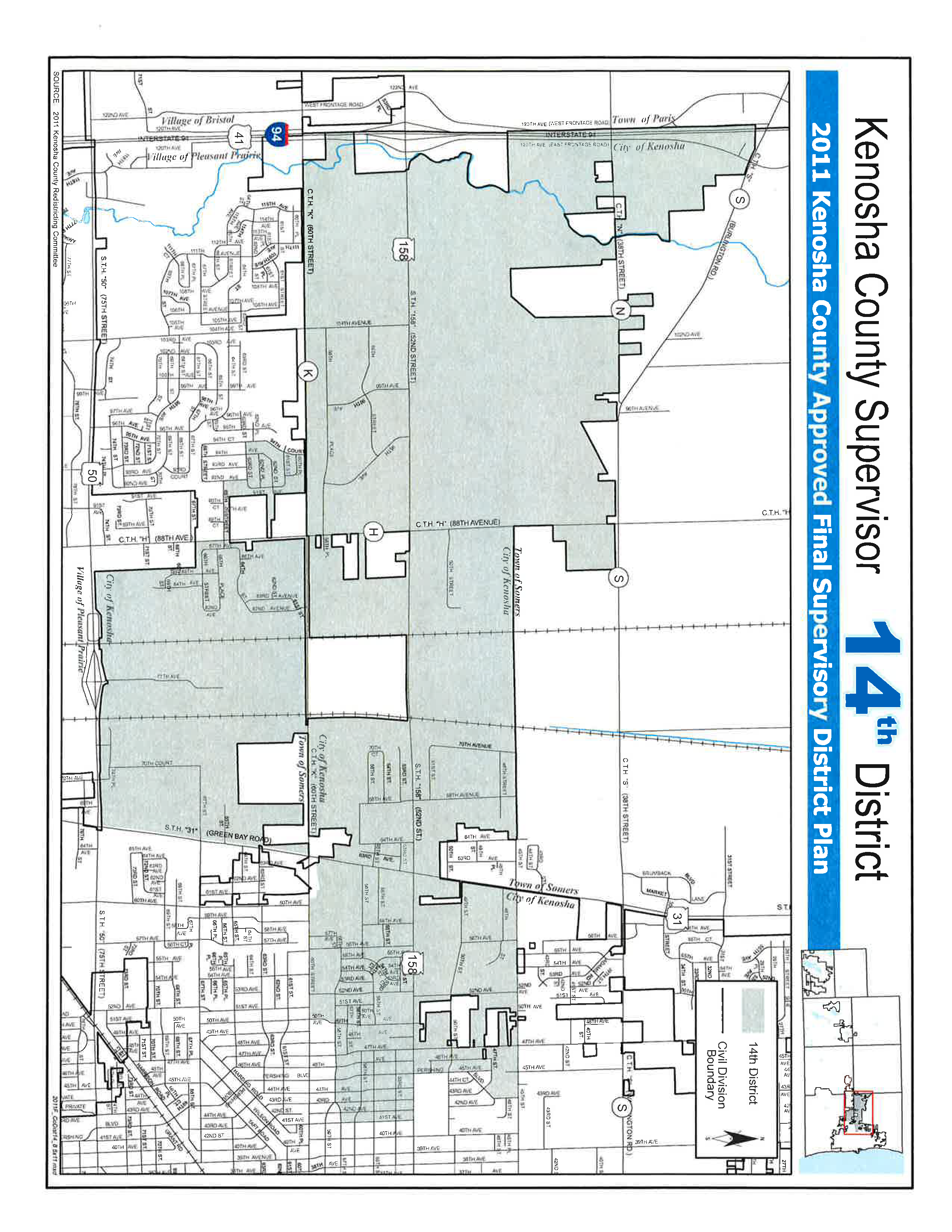
Commence on the centerline of County Trunk Highway “H” said point being the Southeast corner of the Northeast Quarter of Section 5, Township 1 North, Range 22 East of the Fourth Principle Meridian; thence Northerly along the centerline of said road to the intersection with the centerline of 65th Street; thence Westerly along the centerline of said road to the intersection with the centerline of 92nd Avenue; thence North along the centerline of 92nd Avenue to the intersection with the centerline of 63rd Street; thence Westerly along the centerline of 63rd Street to the intersection with the centerline of 94th Court; thence Northerly along the centerline of 94th Court to the intersection with the centerline of 60th Street; thence Westerly along the centerline of 60th Street to a point being the intersection of 60th Street with the West line of parcel 08-222-31-401-001; thence Northerly along the West line of said parcel to the intersection of the West line with the centerline of State Trunk Highway “158”; thence Northerly and Westerly from the centerline of State Trunk Highway “158” to the intersection with the Kilbourn Road Ditch said ditch comprising the West boundary line of parcel 08-222-32-101-004; thence Northerly along said ditch and West line of said parcel to the South line of the Southwest Quarter of Section 30 Township 2 North, Range 22 East of the Fourth Principle Meridian, thence West along said South line to the Southwest corner of the Southwest Quarter of said Section 30; thence North along the West line of the Southwest Quarter and the Northwest Quarter of Section 30 to the Northwest corner of the Northwest Quarter of said Section 30; thence continue North along the West line of the Southwest Quarter of Section 19 Township 2 North, Range 22 East of the Fourth Principle Meridian to the point of intersection of said West line of Section 19 with the centerline of State Trunk Highway “S” extended Northwesterly; thence Southeasterly along the centerline of State Trunk Highway “S” to a point being the intersection of said road with the Northeast corner of parcel 08-222-400-001 extended North; thence South along the East line of said parcel to the Southeast corner of said parcel; thence East along the North line of Section 33 and the North line of the Northwest Quarter of Section 34 to the North Quarter corner of said Section said point also being the intersection of the centerline of 45th Street with the West line of 64th Avenue; thence South along the West line of 64th Avenue to the Southeast corner of parcel 08-222-34-201-051; thence West along the South line of said parcel to the East line of parcel 08-222-34-201-030; thence South along the East lines of the aforementioned parcel and parcels 08-222-34-201-045, 08-222-34-202-006 and 08-222-34-276-001 to a point where the East line of parcel 08-222-34-276-001 intersects the Northwest corner of Certified Survey Map 644; thence East along the North line of said Certified Survey Map 644 to the centerline of State Trunk Highway “31”; thence Northerly along said centerline to the intersection with the centerline of 45th Street; thence Easterly along the centerline of 45th Street to the intersection with the centerline of Pershing Boulevard; thence Southerly along the centerline of Pershing Boulevard to the intersection with 47th Street; thence Northwesterly along the centerline of 47th Street to the intersection of the centerline of 45th Avenue; thence Southerly along the centerline of 45th Avenue to the intersection with the centerline of Pershing Boulevard; thence Southerly along the centerline of Pershing Boulevard to the intersection with the centerline of 52nd Street; thence Easterly along the centerline of 52nd Street to the intersection with the centerline of 41st Avenue; thence South along the centerline of 41st Avenue to the intersection with 57th Street; thence Westerly along the centerline of 57th Street to the intersection with the centerline of 58th Street; thence Westerly along the centerline of 58th Street to the intersection with the centerline of 49th Avenue; thence Southerly along the centerline of 49th Avenue also known as parcel 08-222-35-380-016 to the intersection with the centerline of 60th Street; thence Westerly along the centerline of 60th Street to the intersection with the centerline of State Trunk Highway “31”; thence Southerly along the centerline of State Trunk Highway “31” to intersection with the centerline of State Trunk Highway “50”; thence Westerly along the centerline of said highway to the intersection of the West line extended of parcel 03-122-04-326-003; thence Northerly along the West line of said parcel to the intersection with Neuvillage subdivision; thence Northerly along the West line of said subdivision to the South line of Leona’s Rolling Meadows Addition No 1 subdivision; thence Westerly along the South line of said subdivision to the place of beginning. Excepting therefrom lands that are administered by the Town of Somers, the Village of Pleasant Prairie and highway dedications.
Population of District - 7146 | Percentage of Target 98.75% | % Black 13.99% | % Hispanic 19.97% |