1.05 County supervisory district 5.
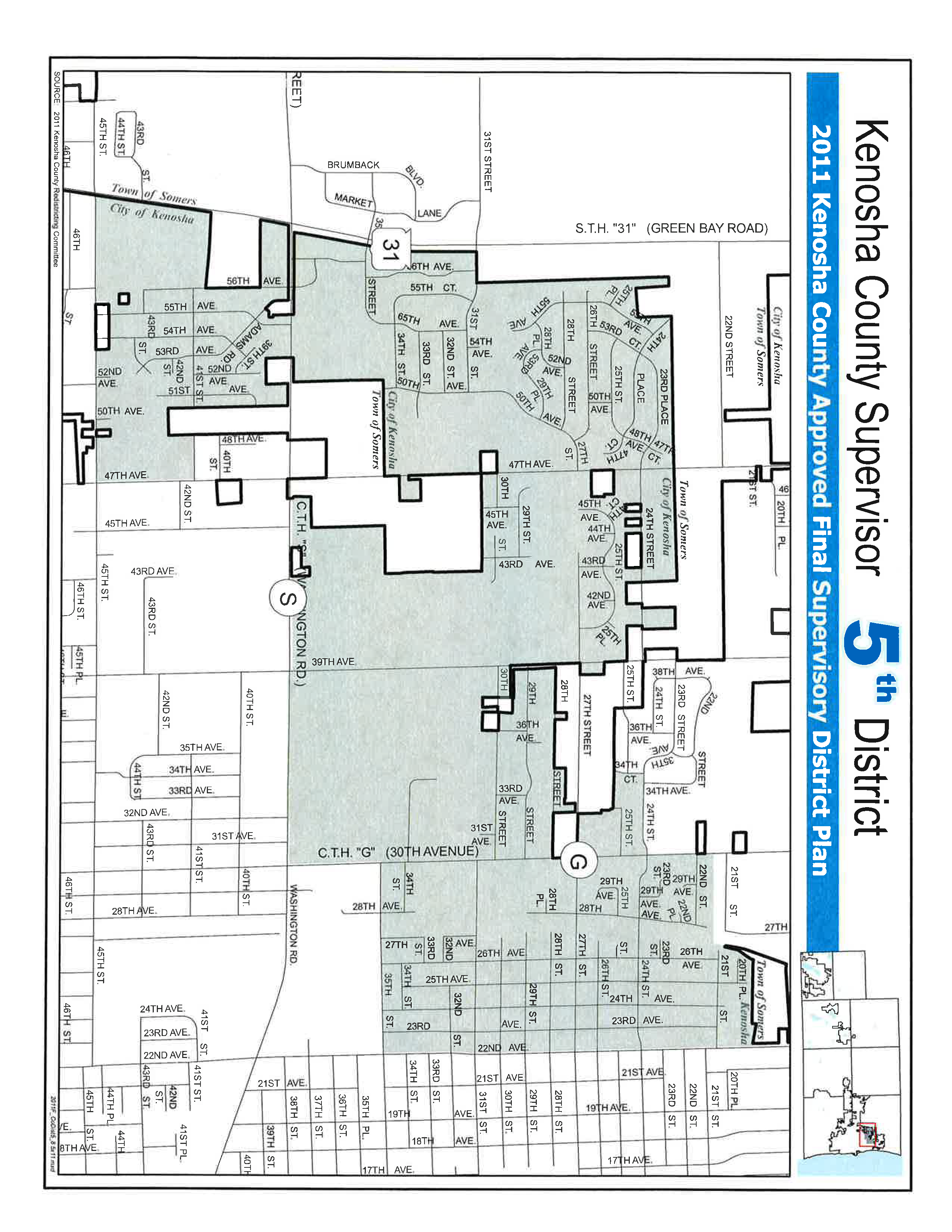
Commence at the intersection of the centerline of 45th Street with the reference line for State Trunk Highway “31”; thence Northerly along the reference line and the East line of State Trunk Highway “31” to a point being the North line of 31st Street; thence Easterly along the North line of 31st Street to the West line of Lot 1 Certified Survey Map 2628; thence Northerly along the West line of said Certified Survey map and the West lines of First Addendum to Hidden Grove Condominiums, Hidden Grove Condominiums, Walnut Grove Addition No 2 and Stonefield Subdivision Addition No. 5 to the Northwest corner of said Stonefield Subdivision Addition No. 5 said point being the Northwest corner of the Southwest Quarter of Section 23 Township 2 North Range 22 East of the Fourth Principle Meridian; thence East along the North line of said Southwest Quarter to the Northeast corner of said Quarter Section said point also known as the Northwest corner of the Southeast Quarter of Section 23 Township 2 North Range 22 East of the Fourth Principle Meridian; thence East along the North line of said Southeast Quarter to a point being 129.32 feet West of the Northeast corner of said section; thence South 436.99 feet to the North line of 24th Street; thence East to the intersection with the centerline of 39th Avenue; thence South along the centerline of 39th Avenue to the intersection with the North line of 28th Street; thence Easterly along the North line of 28th Street to the intersection with the centerline of 30th Avenue; thence North along the centerline of 30th Avenue to the intersection with the North line of 27th Street; thence West along the North line of 27th Street to the Southwest corner of parcel 07-222-24-302-385; thence North along the West line of said parcel to the South line of St. Peter’s Village-A Condominium (Phase 2); thence West approximately 36 feet to the West line of said Condominium; thence North along the said West line 161 feet; thence West to a point on the centerline of 34th Avenue said point being on the South line of Chestnut Valley Subdivision; thence Northeasterly along the centerline of 34th Court to the intersection with the centerline of 24th Street; thence Easterly along the centerline of 24th Street to the centerline of 30th Avenue; thence Northerly along the centerline of 30th Avenue to the intersection with the North line of Heritage Green Subdivision; thence Easterly along the North line of Heritage Green Subdivision to a point being the Southeast corner of parcel 07-222-24-175-005; thence Northeasterly along the East line of said parcel to the South line of Sun Pointe Condominium Addendum No.1; thence Southeasterly to a point on Lot 1 Haugaard Court Subdivision being the West line of said subdivision; thence Northerly along the West line of Haugaard Court Subdivision to the Northwest corner of said subdivision; thence East along the North line of said subdivision and the North line of parcel 07-222-24-176-003 to the West line of parcel 07-222-24-103-008; thence North along the West line of said property 94.62 feet; thence Easterly along the North line of said property to the centerline of 22nd Avenue; thence South along the centerline of 22nd Avenue to the intersection with the centerline of 35th Street; thence West along the centerline of 35th Street to the intersection with 30th Avenue; thence South along the centerline of 30th Avenue to the intersection with the centerline of Washington Road; thence Westerly along the centerline of Washington Road to the intersection with the centerline of 47th Avenue; thence North along the centerline of 47th Avenue to a point where the centerline of said road intersects the Northeast corner of parcel 08-222-26-280-350; thence West along said parcel 554.77 feet; thence South along the West line of said parcel extended to the South line of County Trunk Highway “S”; thence West along the said South line to the Northeast corner of parcel 80-4-222-263-0111; thence South along the East line of said parcel to the intersection with the centerline of 41st Street; thence East along the centerline of 41st Street to the intersection with 47th Avenue; thence South along the centerline of 47th Avenue to the intersection with the centerline of 45th Street; thence Westerly along the centerline of 45th Street to the place of beginning. Excepting therefore lands that are administered by Somers Township.
Population of District - 7171 | Percentage of Target 99.10% | % Black 4.66% | % Hispanic 7.13% |